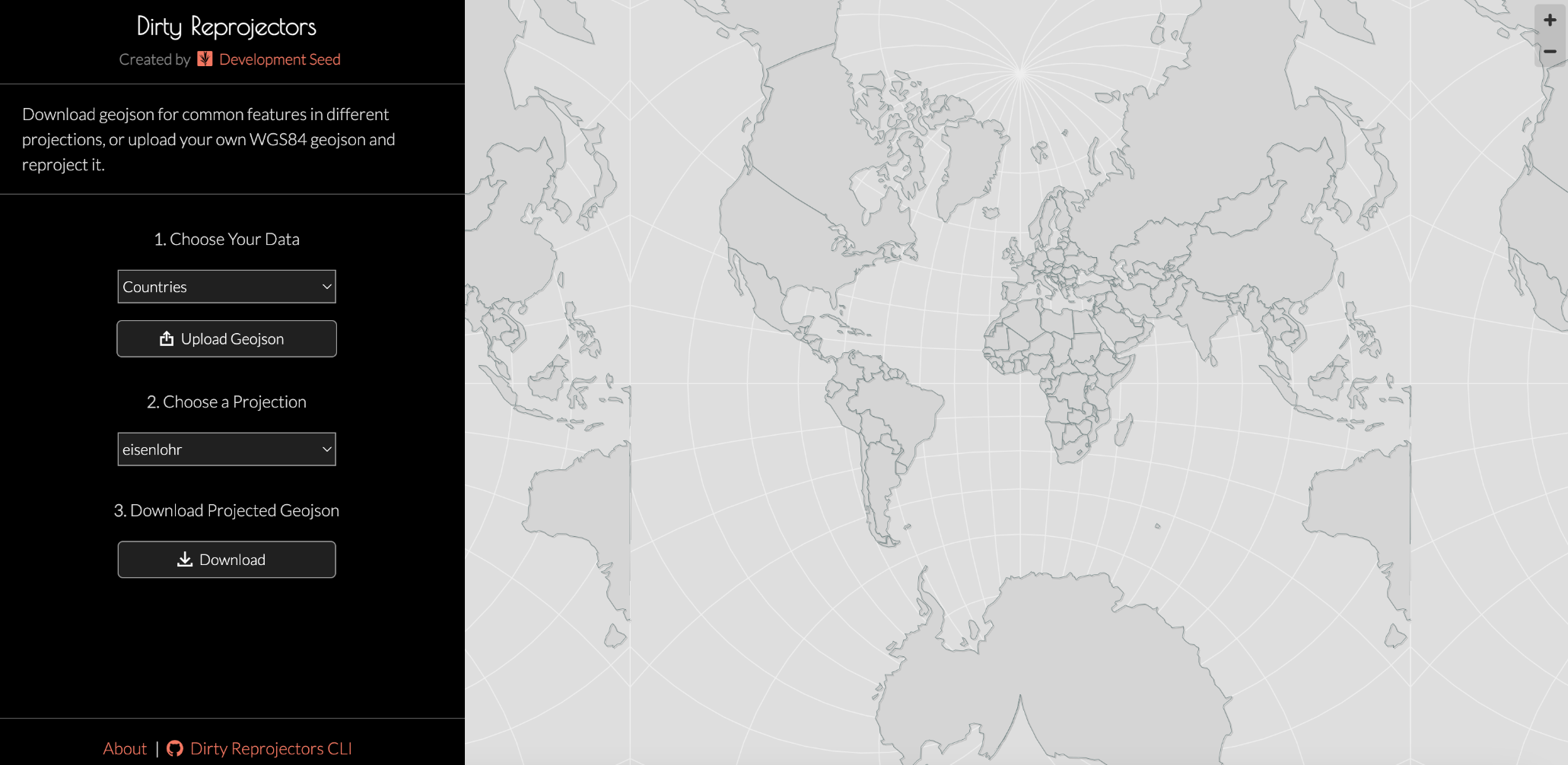
mastouille.fr est l'un des nombreux serveurs Mastodon indépendants que vous pouvez utiliser pour participer au fédiverse.
Mastouille est une instance Mastodon durable, ouverte, et hébergée en France.

Administré par :

Statistiques du serveur :

690
comptes actifs

#webmapping

0 message0 participant0 message aujourd’hui

Seeking recommendations for a #WebMapping tutorial / course?

Slightly at sea on where to start.

- My current JS skill level is _extreme novice_.
- I don't have access to ArcGIS.
- Comfortable with #QGIS [*] and the #python #geospatial ecosystem (#geopandas #xarray #rasterio and plotting with #matplotlib)

Suggestions welcome. TIA. 👍

* I have looked at the qgis2web plugin, but having some issues associated with my aged laptop (2012 mbp running Ubuntu) and a 'Wayland session'.

Australia’s Support To Pacific Surges As China Focuses On ‘Friendly’ States, [Lowy Institute Pacific ] Aid Map Shows
--
theguardian.com/australia-news <-- shared media article
--
pacificaidmap.lowyinstitute.or <-- Lowy Institute Pacific Aid Map
--
[as someone who has spent time on many of these places, islands, this was of particular interest as a way of indicating geopolitics, applied finance, etc]
#GIS #spatial #mapping #geopolitics #aid #SouthPacific #aid #PacificIslands #Pacific #finance #aidevelopment #PacificAid #pacifica #LowyInstitute #PacificAidMap #internationalbusiness #internationalaffairs #spatialanalysis #budget #money #support #foreignaid #transparency #donors #opendata #webmapping #Australia #China #influence #development #developmentfinance
@LowyInstitute

Soar | The New Atlas
--
soar.earth/maps <-- SOAR home page
--
[sharing the details of this web page / service does not constitute an endorsement]
“A digital atlas for all the world's maps and imagery ##
Soar is the world's largest online atlas, and the home of maps on the internet.
[Their] platform allows anyone in the world to view, upload, discover, and interact with an enormous library of high quality maps and images. We’re bringing together every map, satellite, and drone image that has ever existed, or will ever exist, in one place…”
#GIS #spatial #mapping #webmapping #global #resource #remotesensing #clearinghouse #online #onlinemapping #spatialdata #map #satellite #drone #imagery #spatialanalysis
@Soar_Earth

Tomorrow at the University of Guanajuato, within the "Engineering Week" event, I will be presenting, as part of the Official QGIS Mexico User Group :qgis:, the #GIS :earth_photo: of the Government of #Guadalajara 🇲🇽 done in the last two years of work (Only the new developments)
Using #FOSS geospatial :osgeo:
#QGIS #Potree #PostGIS #Geoserver #Leaflet #OpenDroneMap #WebODM #WhiteboxTools #Lastools #CloudCompare #GeoSAM
For #LiDAR #webmapping #drones #photogrammetry #cadastral #survey #AI #mobility

Geomob Podcast 181 - Peter Rushforth - Maps For HTML
--
thegeomob.com/podcast/episode- <-- shared podcast
--
maps4html.org/ <-- Maps For HTML project page
--
“The Maps for HTML Community Group is working to standardize methods of defining interactive geographic maps for the web.”
--
“This week Ed chats with Peter Rushforth from the Maps for HTML project. This is an open source project with accessibility at the centre of their work. With their "lead by example" approach, the community has defined a vocabulary to make maps native elements of the web. Peter is convinced that specifying and implementing accessible maps on the web remains not only possible, but also of huge potential benefit to society….”
#GIS #spatial #mapping #MapsForHTML #webmap #webmapping #standards #opensource #openaccess #specifications #documentation #gischat #communityengagement #crowdsourcing #HTML #webpages #maps #accessiblemaps #web #society #community #podcast #project #geomob
@Geomob @MapsForHTML